


Policy Intervention can make our megacity EQ-Risk free
Dhaka megacity contains more than 10 million populations. Of which most of the peoples are vulnerable to EQ hazard. Main reasons are-
- City is very much unplanned
- It is in the eq hazard zone
- Buildings especially KPIs are vulnerable to eq.
- Most of the buildings are UBM
- Building code not being followed by the builders and owners
- Bldg. code itself outdated
- Life lines does not met eq. code
- Peoples are not aware
- No comprehensive disaster management policy
- No policy, plan or standing order on eq.
- EQ is not very frequent here
- RR measures are not adopted like cyclone
- In case of cyclone DRR measures are-
- Coastal embankment (700 km coast line)
- Cyclone shelter
- Coastal afforestation
- Cyclone preparedness program
- Modernization of early warning generation
- Indigenous techniques adopted for dissemination of early warning
- Concept of CBDRR adopted in the coastal areas
- NGO intervention in livelihood and social education
DRR activities are adopted since 1972, immediately after independence of Bangladesh, for cyclone but for earthquake not yet. Though in 1993 Bangladesh published its National Building Code but not adopt at large. Most of the high rise buildings are more or less considering special provisions for seismic design and construction even before the publication of building code. Since engineering education here follows the curricula similar to USA, engineers and architects are familiar with ACI code, ASTM and so on. In 1982, while designing a 20 storied bank building in a commercial area of capital city Dhaka, I have followed the design and detailing practice what USA had to follow at that time which conforms the basic concept of seismic design and detailing practiced now a days in USA and other countries.
Building code what we have with us from our national standard is not a complete document. No information is there regarding the sub-structural detailing and very little with respect to soil class type. Also no instruction even for structures in the saline zones such as cyclone shelters, suffers much deterioration for not considering any special treatment.
On the other hand, only a building code adoption is not enough for mitigate earthquake risk reduction to a city and to reduce its vulnerability. Lack of micro-zoning map, engineering geological map, fault map etc makes problem more severe. People at large and the communities are not aware mainly because of non-existence of any policy or plan in the national level and lack of imposition of any regulatory bindings and national standard.
Since no major earthquake experienced by the people of this region in last 100 years or more, it is difficult to make people aware regarding the impact and devastation/consequence of an earthquake. There is a Japanese saying ‘the hazard/disaster able to make much destruction/loss which we have forgotten’. That disaster may cause more damage which we are about to forgot.
Unplanned township growth:–
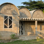
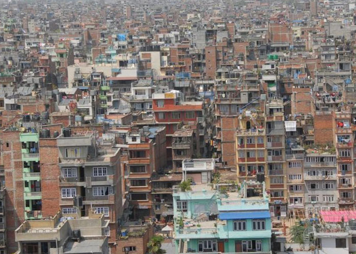
Original town Dhaka in the 20th century started to develop in the soil of Pleistocene deposit popularly known as Modhupur deposit which is free from liquefaction. But the structures at the beginning of the city development were unreinforced brick masonry or even some cases mud mortar. Next era is the unreinforced cement-sand mortar. Some 350,000 houses are there in Dhaka super-megacity. Out of which most of them are non-engineered and founded in a soil having soil class D, E or even F. because of non-availability of A, B, C or D type soil, city grown in the E type soil.
Narrow road, lack of park, lake, and playground and so on.
Super mega-city Dhaka is one of the world’s most vulnerable cities. More than 12 million peoples are living here are at risk of earthquake, flood, fire, building collapse etc. Dhaka is not located at most severe earthquake zone or over a fault or plate boundary line. Risk is very high because of its exposure to earthquake hazard. The reason for vulnerability is numerous – no national policy intervention, no act or plan, no master plan yet considering earthquake vulnerability as plan element and so on.
Third world countries like Bangladesh need south-south cooperation.
Examine the best technology to adopt using the advantage of ICT but alternative to hi-tech affordable indigenous technologies keeping in mind ‘build back better’.
Bangladesh is the country of super shopping mall of all the disaster.
Bangladesh has substantial achievement regarding cyclone risk reduction but not at all in case of earthquake hazard. Category 4 cyclones hit Bangladesh during the year 1970, 1991 and 2007 and casualties were 500000, 138000 and 3500. The secret behind the reduction of live losses are adopting risk reduction concept in the policy folder and effective implementation of DRR agendas such as –
- Main streaming coastal volunteer program of International Federation of Red Cross Society by the government of Bangladesh in the year 1973 giving status of GoB & IFRCS joint program and started to build the capacity & extents of CPP.
- Started to build the embankments along the coast line (about 7000 km).
- Creation of green belt through aforestation along the coast line.
- Construction of cyclone shelter for the vulnerable people of High Risk Zone (probability of inundation depth more than one meter due to tidal surge).
- Taking into account the best practices from the community
- Adopting local disaster action plan giving due respect to community knowledge in a participatory manner.
- Recognizing bottom up approach in the policy decision.
- Recognizing due respect to local religion and cultural belief.
- Recognizing community resilience developed.
- Adopting the technique of community based disaster risk reduction.
__________________________________________________________________________
Bangladesh a small country having very high population is an underdeveloped country
Bangladesh is one of the most vulnerable countries in the world due to cyclone and tidal surge because of following reasons:
- % of worlds total tropical cyclone forms in the bay of Bengal
- % of which had landfall to Bangladesh
- Estuary of —- nos of rivers to brings the tidal surge inland
- Elevation of land formation is not very high with respect to sea level
- Very poor coastal population
- Not enough coastal embankment by length or by height
- False sense of security due to existing embankment
- Not enough green belt or afforestation
- Shallow continental shelf
- Not good enough communication system for dissemination of early warning and evacuation etc.
- No redundant tele-communication system
- No loud speaker network
- No forecasting of inundation height due to tidal surge
- No digital terrene model
- No or low maintenance of folder, dyke and fails due to surge